Part of the purification process for one stricken with tzara'as — leprosy, is the bringing of two birds. The selection of birds to serve as atonement for this leper having succumbed to the sin of slander, is to remind us that it all starts with theפטפוטי דברים — purposeless 'chatter', like birds who twitter constantly with chirping sounds.
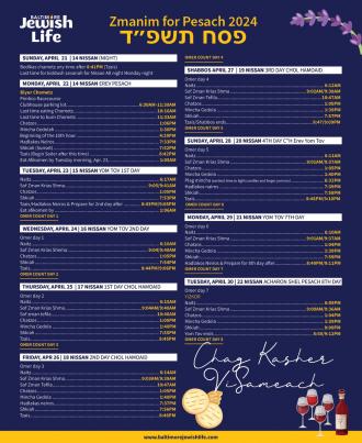
The coincidence of Shabbos HaGadol with the weekly portion that addresses the rectification of derogatory speech, draws us to a mystical teaching of the Holy Arizal regarding the deeper meaning of the name of the holiday of פסח — Pesach.
He writes that this word which is usually associated with its meaning to 'skip over', alluding to how on the night of the Plague of the Firstborn, G-d skipped over the houses of His children who painted their doorposts and lintels with the blood of their Paschal lambs, has an additional connotation.
The word פסח is a contraction of two words, פה סח — the mouth talks.
On the simplest level it reflects on the nature of the primary obligation of this holiday — to retell the story of the exodus to our children. The many other mitzvos — eating Matzah, Marror, and the Paschal lamb when the Temple stood, are intended to prod the discussion that brings us back to that historic moment with all its details and symbolism, and the mission to recall and implement the message behind it all. That message being G-d's total mastery over the world and His commitment to the children of Avraham, Yitzchok, and Yaakov.
But the Arizal tells us there is much more to it than the fact this command in particular calls for much talk. He mentions the notion of דיבור — speech, having been in גלות — exile, finding redemption with their newfound discovery of a unique ability to communicate.
The great Rosh HaYeshiva and profound thinker, Rav Yitzchok Hutner, points out that the word פלא which means wonders, also means to 'express words', as when the Torah talks about taking a vow it describes his verbalization as a man כי יפליא.
Just as when man observes the נפלאות — wondrous ways of G-d's intervention in nature, as in the splitting of the sea, where the Torah states His having עושה פלא — performed wonders, manipulating the physical world to execute G-d's wondrous miracles, so too when man exercises his soul infused intellect, prodding him to utilize man's unique talent of verbal expression to fuse the power of his spiritual soul with his physical body in producing 'words' and meaningful speech, is equally described as a פלא — wonder.
It was after being enlightened by all the נפלאות — miracles of G-d that led to the exodus, culminating with the splitting of the sea, with our singing Az Yashir, that we also were redeemed from our former 'silence' in now devoting our very essence in 'expressing' wondrously G-d's praise, that we redeemed 'speech' from its exile.
But what leaves us wondering is the specific term of used in describing our unique quality of פה סח — literally a mouth that 'converses'.
שיחה — Sicha seems to emphasize a conversation, almost something casual and intimate. In what way does this relate to the formal obligation to intentionally find the accurate words in expressing properly the story of the exodus?
To uncover the deeper meaning within this teaching of the holy Arizal please join me this Shabbos afternoon at the Shabbos HaGadol Derasha at the Ohel.
Hope to see you.
באהבה,
צבי יהודה טייכמאן